Sky · Real spacecraft, public optics

The spacecraft are real. This is who photographs them.

In live mode the console flies catalogued objects. This page collects the public telescopes, cameras and feeds that photograph satellites from the ground and from orbit, and the Earth from orbit. A picture is hosted here only where its licence allows it; everything else is a plain link to the photographer. Nothing on this page is a product screenshot.

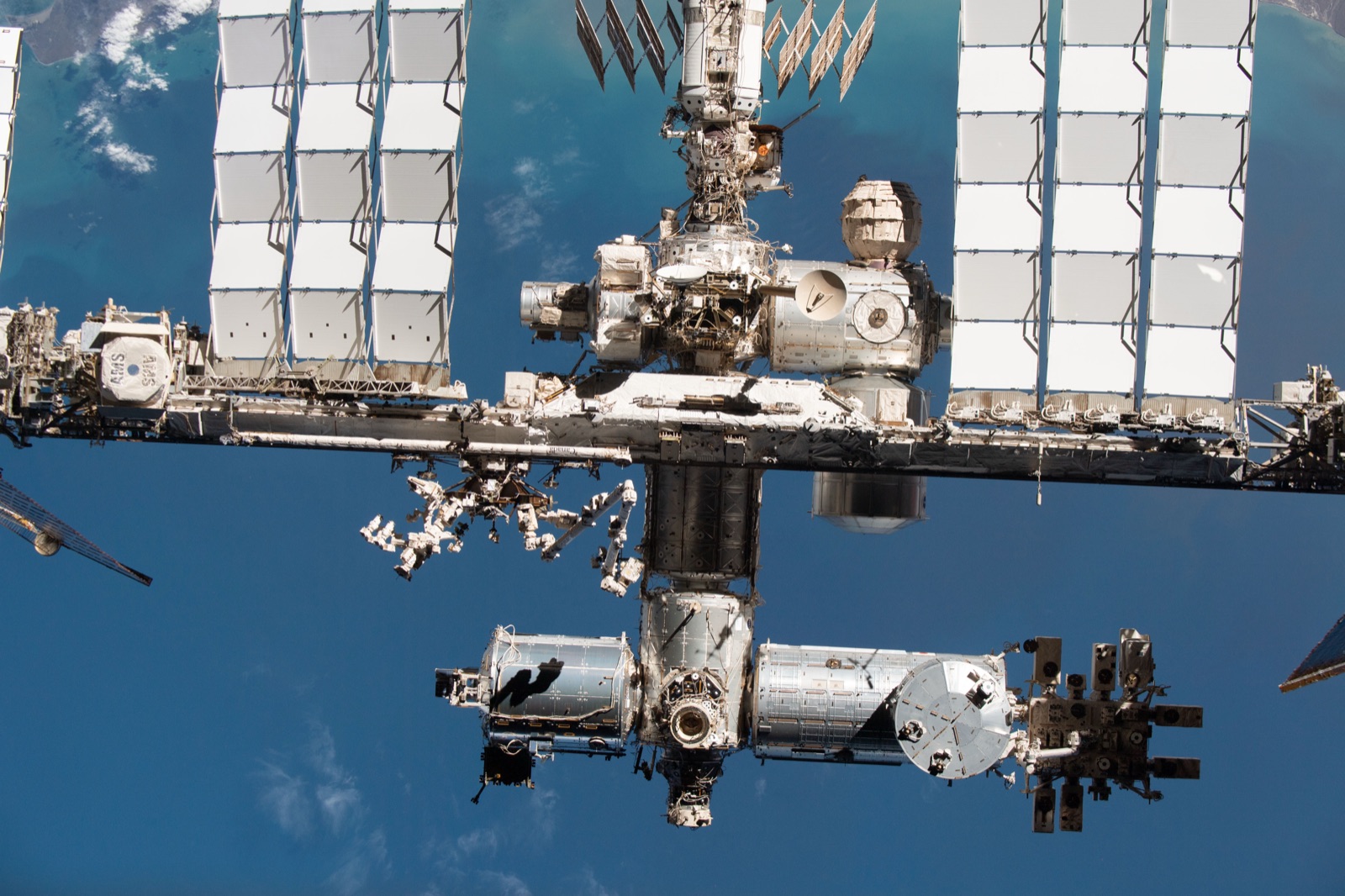
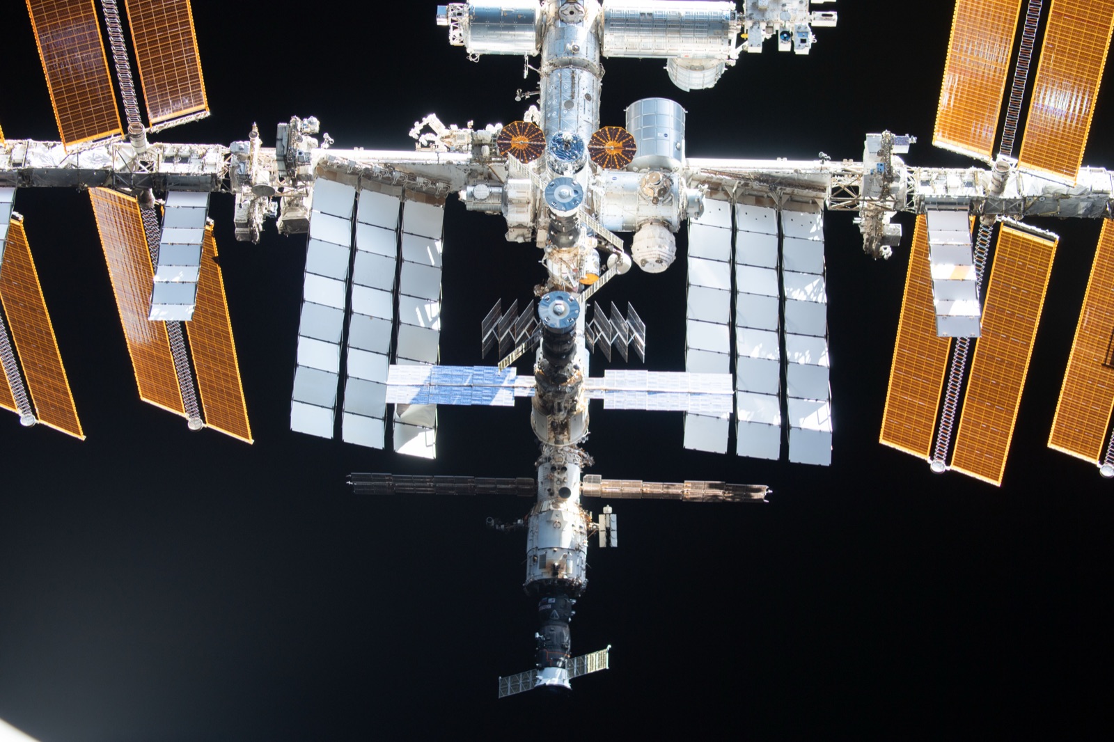
The International Space Station seen from a few hundred metres away against the blue limb of the Earth, photographed from Crew Dragon Endeavour during the Crew-2 flyaround.
The Space Station from Crew Dragon Endeavour, 8 November 2021, during the Crew-2 departure flyaround.
Credit: NASA/Thomas PesquetNASA, public domainTaken 2021-11-08SourceRetrieved 2026-09-12
Documented
How to read this page

Hosted with a licence, or linked. There is no third option.

Every hosted image carries its credit, the licence that permits hosting, the page it was retrieved from and the date. No embedded player, widget or iframe appears anywhere on this site, so no photograph here sets a cookie or loads a script.
What is deliberately absent.
  • No embedded players, widgets or iframes. Every third party on this page is a plain link.
  • No image under an ESA Standard Licence, which excludes marketing use. Only ESA material marked CC BY-SA 3.0 IGO is hostable.
  • No frames from NASA Johnson’s Flickr account, which carries a non-commercial tag on images that are public domain on nasa.gov.
  • No Planet or Vantor imagery: the public galleries are non-commercial, and the rest needs written approval.
  • No claim of an Airbus Pleiades Neo image of the Space Station. It is widely repeated and could not be traced to a source.
  • No "new" crewed flyaround. Articles dated 2025 reuse the 2021 frames without saying so.
  • No amateur photograph hosted without written permission, however often it has been reposted elsewhere.
Seen from the ground

A telescope can resolve a spacecraft. Keeping it in the frame is the hard part.

The Space Station crosses the sky in a few minutes and the solar disc in under a second. The people and observatories here track it well enough to photograph it, which is the same pointing problem a power link has, solved in public.

Ground-based DSLR and telescope, solar filter, transit predicted to the second

NASA photographers, ISS transits

NASA

The Space Station silhouetted against the Sun and the Moon, including during the 12 August 2026 total eclipse.

Why it matters

A transit is a pointing and timing problem: the photographer has to be on a line a few kilometres wide at a predicted second. That is the geometry a ground station lives by.

The limit

A stills camera on a tripod is not a tracking mount. The Station is resolved because it is large and close, not because the camera followed it.

NASA Image and Video Library
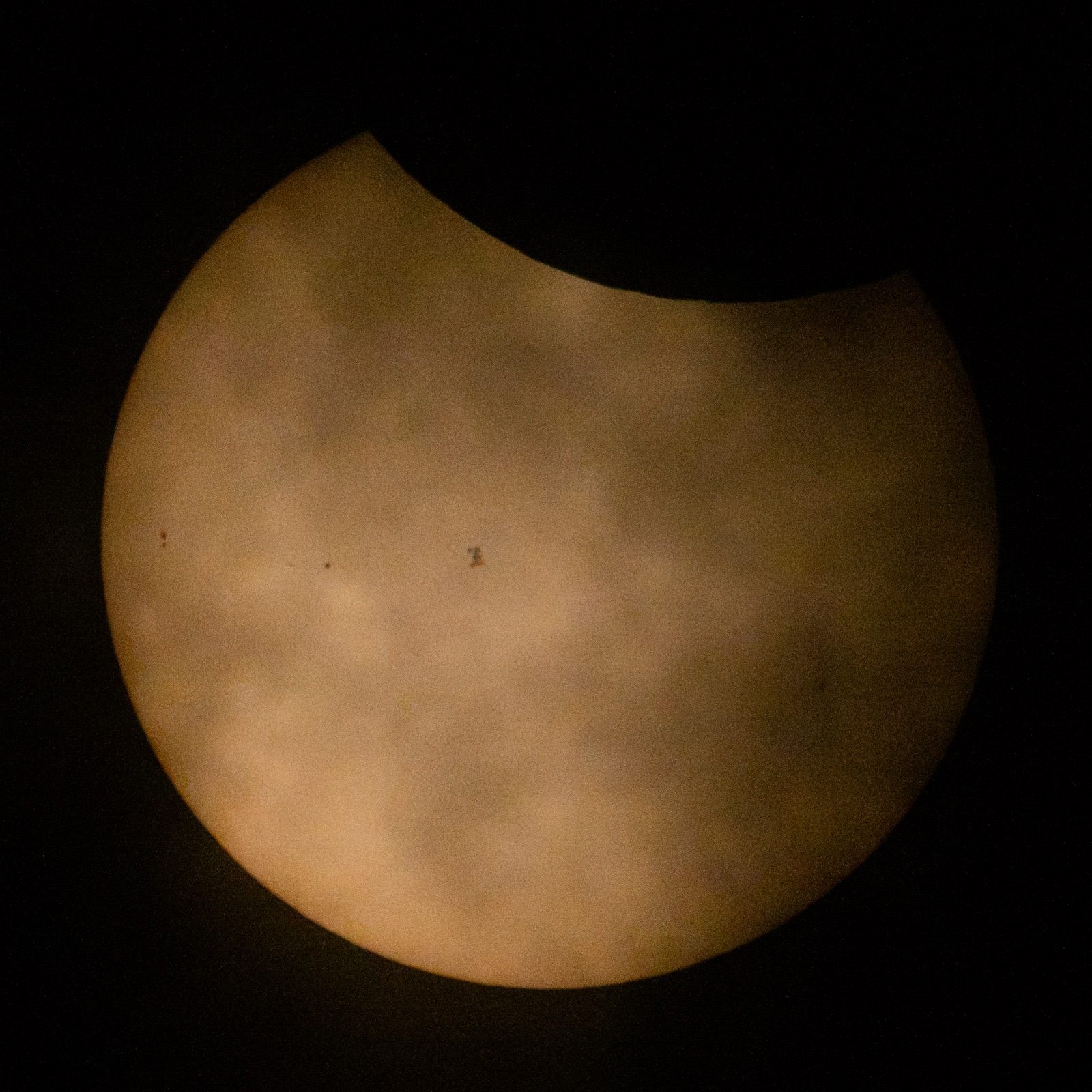
The International Space Station as a small dark silhouette on the face of the Sun, with the Moon covering the upper edge, photographed from the ground on 12 August 2026.
The Space Station crossing the Sun on 12 August 2026, with the Moon already taking a bite from the top. Partial from where the camera stood; a transit lasts under a second, and the pointing and timing are the whole photograph.
Credit: NASA/Joel KowskyNASA, public domainTaken 2026-08-12SourceRetrieved 2026-09-12
Documented
Three sites of 1 m class telescopes: Socorro, Maui, Diego Garcia

GEODSS

US Space Force

Deep-space surveillance of geosynchronous orbit. The facility is photographed; its data is not public.

Why it matters

This is what a national optical tracking network looks like: modest apertures, wide fields, and geography chosen to cover the whole geostationary belt.

The limit

GEODSS produces catalogue observations, not pictures. Nothing it sees is published as an image, so the photograph is of a dome.

Facility photographs on DVIDS
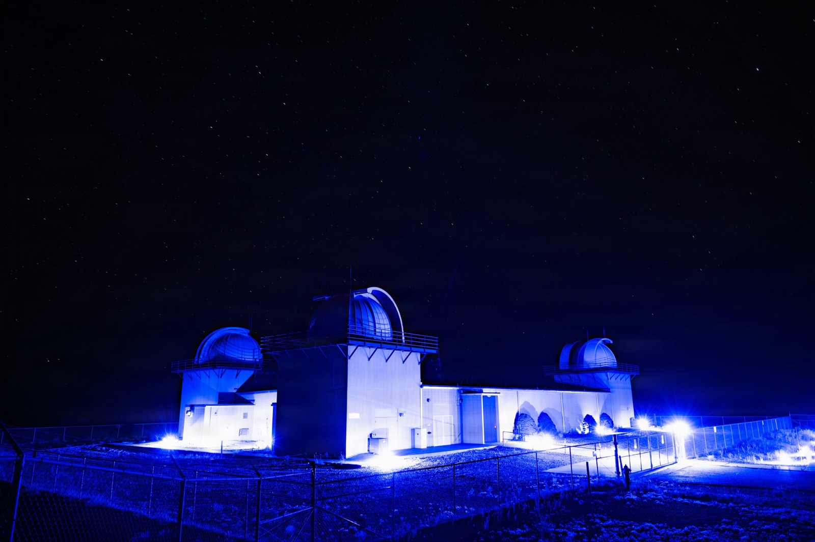
Three Ground-based Electro-Optical Deep Space Surveillance telescope domes at White Sands, New Mexico, lit blue at night under a starry sky.
The GEODSS telescope domes at White Sands, New Mexico, at night, after the 2026 sensor upgrade. One of three sites that watch geosynchronous orbit for the US Space Force.
Credit: U.S. Space Force photo by David Grim, via DVIDSUS Government work, public domainTaken 2026-06-15SourceRetrieved 2026-09-12
The appearance of U.S. Department of War visual information does not imply or constitute endorsement.
Documented
Prediction service, not a camera

ISS Transit Finder

Bartosz Wojczynski

When and where the Space Station, Hubble or Tiangong will cross the Sun or Moon from a given location.

Why it matters

Every transit photograph on this page started here or somewhere like it. The prediction is the photograph.

The limit

A prediction is only as good as the element set it was computed from, which is the same caveat the console prints on every pass.

transit-finder.com
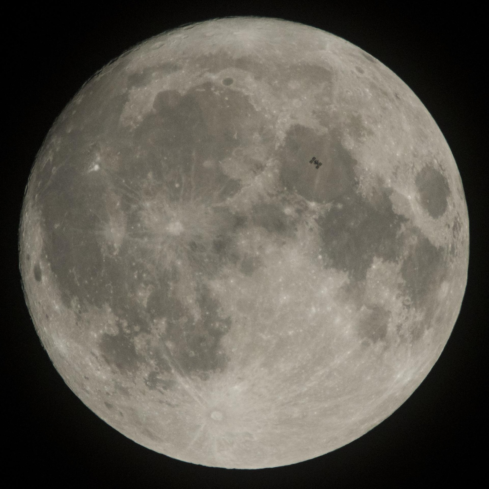
The International Space Station as a small silhouette against the face of the Moon, photographed from Pennsylvania on 2 December 2017.
The Space Station transiting the Moon, 2 December 2017, at roughly eight kilometres per second.
Credit: NASA/Joel KowskyNASA, public domainTaken 2017-12-02SourceRetrieved 2026-09-12
Documented
1.3 m Meter Class Autonomous Telescope, near the equator in the South Atlantic

NASA MCAT, Ascension Island

Statistical surveys of orbital debris from low Earth orbit out to geosynchronous, filling the longitude gap in the GEODSS network.

Why it matters

A 1.3 m telescope on a remote island, run autonomously, is the scale of optical ground segment a power-beaming operator would need for its own space-situational awareness.

The limit

MCAT counts and characterises debris. It is not a communications or power terminal, and it does not track a single cooperative spacecraft for minutes at a time.

NASA ODPO optical measurements
Large amateur telescope with custom tracking, France

Thierry Legault

The Space Station and visiting vehicles in close-up, and transits of the Sun and Moon, including with a Shuttle docked.

Why it matters

The canonical proof that an amateur instrument can resolve modules and solar arrays from the ground. If this is possible with one telescope, pointing at a cooperative spacecraft is not the hard problem.

The limit

These are single frames from stacked video, chosen from thousands. A power link has to hold pointing continuously, not pick the best moment afterwards.

astrophoto.fr
250 mm Dobsonian with manual tracking and a planetary camera; a monthly gallery from other amateurs

Space Station Guys

Space Station close-ups with visiting vehicles, Tiangong, and the Space Station Photo of the Month from imagers worldwide.

Why it matters

The best single directory of people who currently photograph spacecraft from the ground, with their equipment listed. It is the map of who could be asked.

The limit

Hand-tracked Dobsonians work because the Station is bright and large. The same method would not find a small spacecraft at 1,000 km.

spacestationguys.com
24-inch PlaneWave on a robotic mount slewing up to 50 degrees a second, Tel Aviv rooftop

Tel Aviv University Optical Ground Station

The Space Station with Starliner and Crew Dragon docked, Tiangong, and other satellites, from a university station built for tracking and optical communication.

Why it matters

An Israeli optical ground station whose stated purpose includes satellite tracking and communication. It is the nearest thing in the country to the instrument a power link needs.

The limit

Optical communication and imaging need milliradian pointing; a power link at range needs microradian pointing and a receiver that can take the flux. Same mount class, different problem.

ISS imaged from Earth, Planetary Society
Fixed cameras with GPS time insertion; a 41.5 cm telescope for faint targets

SatTrackCam Leiden

Satellite trails, identifications of unlisted objects, re-entries, and the original 2019 Starlink train footage.

Why it matters

What a small optical station actually does all night: astrometry, identification, orbit determination. It is the ground truth a catalogue is built from.

The limit

A trail on a fixed camera gives a position, not a picture. This is measurement, and the photographs are a by-product.

sattrackcam.blogspot.com
1 m Zeiss telescope at 2,400 m, with lasers and photon detectors for optical links to LEO and GEO

ESA Optical Ground Station, Tenerife

Monthly surveys of geostationary debris to magnitude 21, and laser communication experiments with spacecraft.

Why it matters

This is an optical ground station that fires a laser at satellites. It is the closest public analogue to a power-beaming ground terminal that exists.

The limit

The laser carries data and ranging pulses at watts, not power at kilowatts. The link closes on a photon counter, not a receiver that turns the beam into electricity.

ESA Space Debris, scanning and observing
Binoculars, stopwatches and cameras, worldwide

SeeSat-L

Text observations and identifications, including of unlisted objects, with links to member images.

Why it matters

Where the ground-based trackers publish first. A public catalogue of who saw what, when, is what independent verification of an orbit looks like.

The limit

Visual timing is accurate to a second and a fraction of a degree. It confirms a catalogue entry; it does not replace one.

satobs.org
Smart telescopes of about 114 mm aperture, networked

Unistellar citizen science

Campaigns including a satellites programme that tracks artificial objects and their effect on the night sky.

Why it matters

A ready-made pathway for a reader who wants to track a satellite themselves tonight with an instrument they can buy.

The limit

A 114 mm aperture sees satellites as points. It will never resolve a spacecraft; it measures where the point is.

science.unistellar.com
Robotic internet telescope, live webcasts for schools

Bareket Observatory

Live observing sessions and an education portal used by the Israeli Ministry of Education.

Why it matters

The Israeli entry point for a class that wants to look through a real telescope over the internet.

The limit

The instrument is built for deep-sky targets. Satellite work is possible on request, not the programme.

bareket-astro.com
Seen from orbit

Satellites now photograph other satellites.

Non-Earth imaging is a business as of the mid 2020s: commercial spacecraft slew to image another object tens of kilometres away and sell the frame. The public examples are the sharpest pictures of spacecraft that exist.

Hand-held camera from Crew Dragon Endeavour, a few hundred metres away

Crew Dragon flyaround of the Station

NASA and SpaceX

The full Space Station from every side, photographed by the Crew-2 astronauts on departure, 8 November 2021.

Why it matters

The reference for what a large spacecraft looks like at close range: the arrays, the radiators, the scale of the structure a beam would have to land on.

The limit

This required a crewed vehicle to undock and fly a circuit. No new crewed flyaround was found for 2025 or 2026, so the reference is five years old.

NASA image article
A second frame from the Crew-2 flyaround, showing the International Space Station solar arrays and modules with the Earth below.
A second frame from the same flyaround, looking down the length of the truss. Nothing on orbit photographs the Station this closely except a spacecraft that has just left it.
Credit: NASANASA, public domainTaken 2021-11-08SourceRetrieved 2026-09-12
Documented
Holmes imager: 94 mm aperture, 0.4 degree field, 2.3 kg, hosted on partner spacecraft

HEO

The Space Station from 69 km, Tiangong assembly over time, and commercial satellites imaged for their operators.

Why it matters

Non-Earth imaging as a product: a small camera, many hosts, and a slew to a target at kilometres per second of relative speed. The pointing problem is solved at scale.

The limit

A 94 mm imager sees a spacecraft as a few pixels at tens of kilometres. It confirms shape and health; it does not resolve detail.

heospace.com
WorldView-3 and WorldView Legion, 30 cm class Earth imagers turned toward other spacecraft

Vantor WorldView

The Space Station, Tiangong and Hubble at down to four centimetres a pixel from tens of kilometres away, 2022 to 2026.

Why it matters

The sharpest public pictures of spacecraft from another spacecraft. They exist because an Earth imager that can slew is already a satellite imager.

The limit

These are the flagship imagers of a large company, pointed at the largest objects in orbit. The result does not generalise to a small camera on a small satellite.

vantor.com
Jilin-1 Earth-imaging constellation

Jilin-1

The Space Station from 305 km in October 2025, and four frames of a WorldView Legion satellite from 40 to 50 km in September 2025, per secondary reporting.

Why it matters

Two operators photographing each other is what space domain awareness looks like from the outside. The pictures themselves are the message.

The limit

Neither the raw frames nor their metadata are public, so nothing here can be checked. The card exists to name the event, not to vouch for the pixels.

Secondary report, Universe Magazine
Three 4K cameras: straight down, along the station, and at the horizon

Sen SpaceTV-1

Live 4K video of the Earth and the station structure, more than twenty hours a day.

Why it matters

The closest thing to standing on a spacecraft and looking out. Useful for seeing how fast the ground moves under a low orbit.

The limit

The stream is a product with its own player and terms. Embedding it would be the first third-party script on this site, so it is a link.

sen.com
Earth from orbit

The public-domain view down.

Weather and science satellites publish the Earth every few minutes under licences that allow anyone to host the file. These are the pictures that show what a receiving site sits under: cloud, which is the line-of-sight constraint the console models.

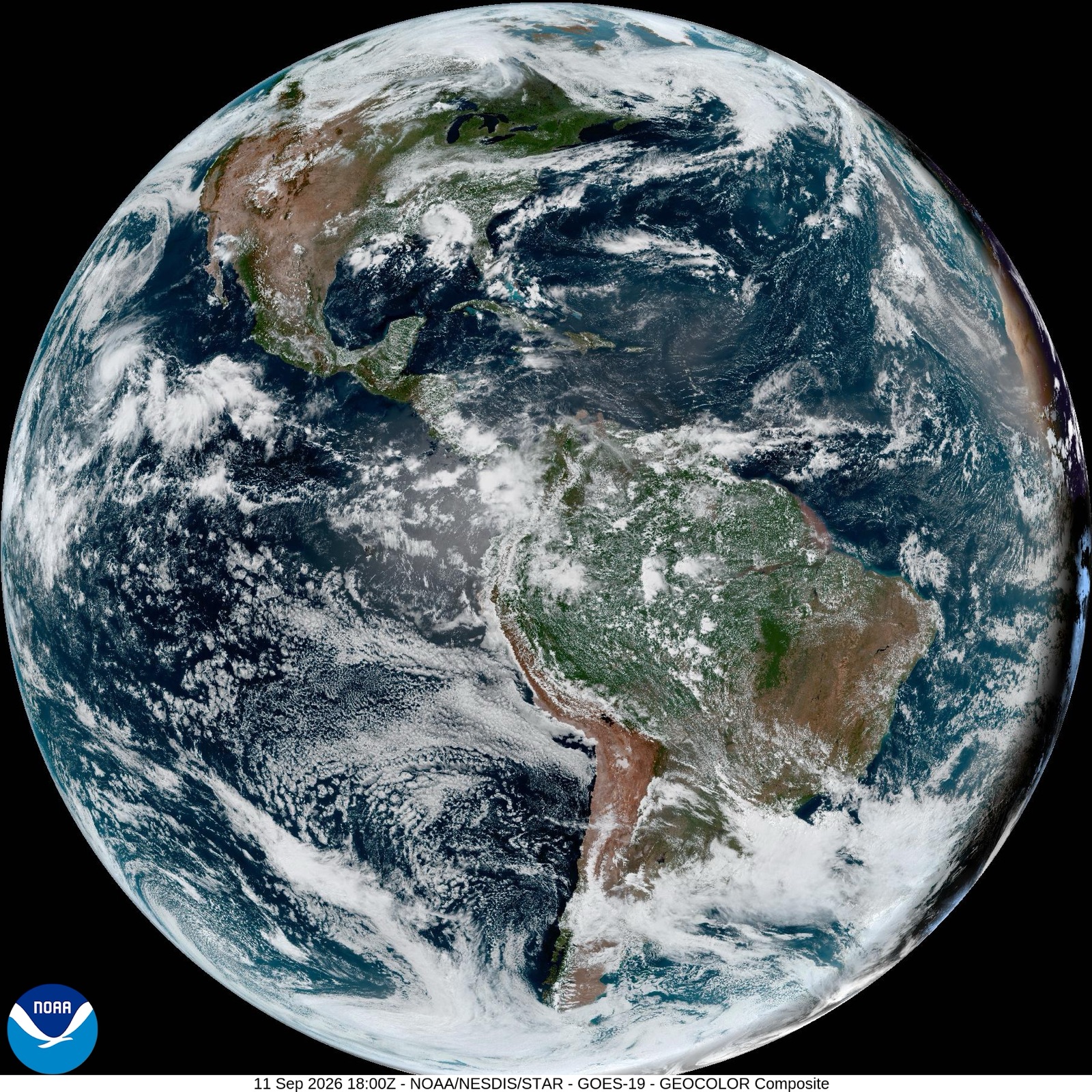
Advanced Baseline Imager in geostationary orbit at 75 degrees west

NOAA GOES-19

NOAA NESDIS STAR

The full disc of the Earth every ten minutes in sixteen bands, with GeoColor composites and lightning mapping.

Why it matters

Cloud is the line-of-sight constraint the console models for every station. This is what that constraint looks like from the satellite side.

The limit

A weather imager at 36,000 km resolves kilometres, not metres. It tells you a site is under cloud, not what the site is.

NOAA STAR GOES imagery
A full-disk GeoColor image of the Earth from the GOES-19 weather satellite in geostationary orbit, showing the Americas with cloud, ocean and land in natural colour.
The Earth from GOES-19, in geostationary orbit over the Americas. A new full disk every ten minutes, in the public domain.
Credit: NOAA/NESDIS STARUS Government work, public domainTaken 2026-09-11 18:00 UTCSourceRetrieved 2026-09-12
Documented
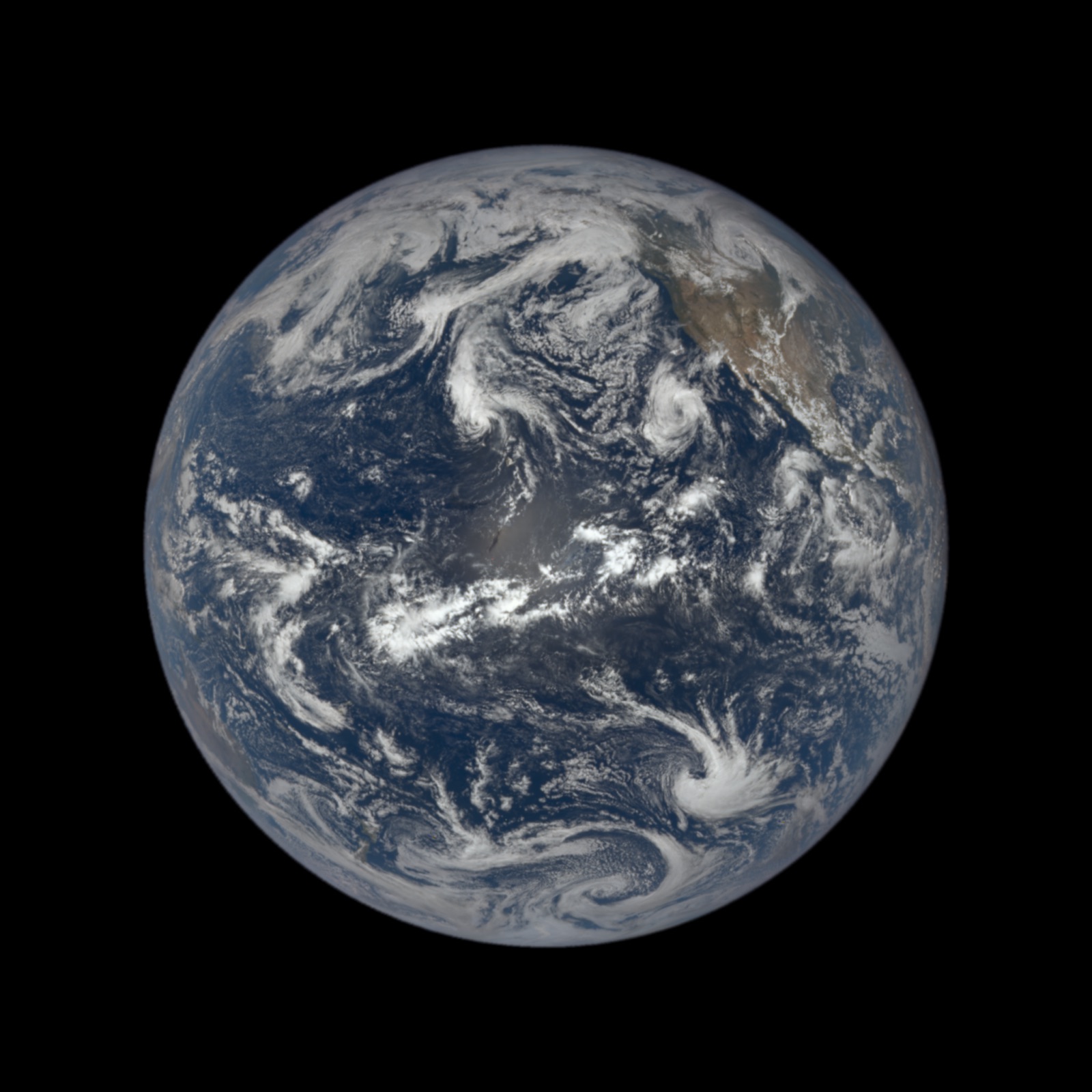
Earth Polychromatic Imaging Camera at the Sun-Earth L1 point

DSCOVR EPIC

NASA and NOAA

The whole sunlit Earth, about a dozen times a day, from 1.5 million kilometres.

Why it matters

The only camera that sees the entire day side at once. It shows which hemisphere is illuminated, which is the other half of every power schedule.

The limit

From L1 the Earth is a few hundred pixels across. It is a picture of the planet, not of anywhere on it.

epic.gsfc.nasa.gov
The sunlit face of the whole Earth from the DSCOVR spacecraft at the Sun-Earth L1 point, about one and a half million kilometres away.
The whole sunlit Earth from DSCOVR EPIC at the L1 point, roughly 1.5 million kilometres out. About a dozen frames a day.
Credit: NASA/NOAA DSCOVR EPICNASA, public domainTaken 2026-09-08SourceRetrieved 2026-09-12
Documented
Sentinel-2 at 10 m resolution, Sentinel-1 radar, and the rest of the fleet

Copernicus Sentinel

Any place on Earth every few days, browsable without an account.

Why it matters

Ten-metre imagery of a candidate site, free to host. This is how a receiving footprint gets checked against what is actually on the ground.

The limit

Optical Sentinel frames are as cloudy as the sky was. For a site under persistent cloud the radar satellite is the useful one, and it is harder to read.

Copernicus Browser
External high-definition camera on the Harmony module

NASA live from the Station

Live Earth views and station operations when the crew is on duty.

Why it matters

The free version of the view from orbit, and the one whose footage may be recorded and reused with credit.

The limit

The older HDEV experiment ended in 2019 and most "ISS live" channels are rebroadcasts of this feed. Go to the source.

nasa.gov/live
An archive and an API with no key required

NASA Image and Video Library

Every public NASA still and clip, searchable, with metadata and originals.

Why it matters

Where every hosted NASA image on this page came from, and where a reader can find the original.

The limit

Items with third-party copyright are mixed in and marked. The library being public domain does not make every item in it so.

images.nasa.gov
Watch it move

Pass predictions and orbit viewers, live.

Not photographs, but the same catalogue numbers the console flies in live mode, drawn by other people. Go outside at the predicted minute and the point of light is there.

Consumer camera, tripod, night sky

A Starlink train, filmed from the ground

Jud McCranie, Wikimedia Commons

Sixty freshly launched satellites in a line, before they raise their orbits and disperse.

Why it matters

A constellation is visible to the naked eye for a few nights after each launch. This is what many spacecraft in one plane look like, which is the shape of a power fleet.

The limit

The train is a launch artefact. Within weeks the satellites are hundreds of kilometres apart and invisible without a prediction.

Starlink seen from Earth, Wikimedia Commons
A Starlink train shortly after launch, before the satellites raise their orbits and spread out. Forty seconds, filmed from the ground. The still shown before the clip plays is a different photographer’s long exposure of an earlier train.
Credit: Jud McCranie, CC BY-SA 4.0, via Wikimedia CommonsCC BY-SA 4.0Taken 2020-04-30SourceRetrieved 2026-09-12
Poster: Mike Lewinski, Starlink Overpass No 1, 26 May 2019CC BY 2.0Source
Documented
App and website with an augmented-reality pass view

NASA Spot the Station

When the Space Station will pass over a location, how high, and for how long.

Why it matters

The simplest way for a reader to see a spacecraft with their own eyes at a predicted minute.

The limit

One object. It does not show the rest of the sky the console draws.

nasa.gov/spot-the-station
Browser 3D visualisation of the Earth-science fleet

NASA Eyes on the Earth

Where each NASA Earth satellite is now, and the measurement it is taking.

Why it matters

A well-made public view of a real fleet in real orbits, which is what the console constellation view is, for a different fleet.

The limit

It shows the NASA science fleet only, and it runs a heavy 3D application that this site will not embed.

eyes.nasa.gov
Pass predictions, sky charts and a 3D orbit view for every catalogued object

Heavens-Above

Visible passes of the Space Station, Starlink batches, Tiangong and anything else with a catalogue number.

Why it matters

The standard tool for going outside tonight. In live mode the console next-window panel links straight to the object it is showing.

The limit

Predictions are only as fresh as the element set. Newly launched or manoeuvring objects are wrong for a day or two.

heavens-above.com
Real-time tracking pages and a keyed API with hourly limits

N2YO

Position, ground track and upcoming passes for any catalogued object.

Why it matters

The second tracker the console links to in live mode, so a reader has two independent answers for the same object.

The limit

Two trackers reading the same element set agree by construction. Independent confirmation needs an observation, not a second propagator.

n2yo.com
3D orbit visualisation from the same element sets the console fetches

CelesTrak orbit viewer

Any catalogue group as orbits around the Earth, in a browser.

Why it matters

This is the console fleet provider. Seeing the same group drawn by its source is the cheapest cross-check available.

The limit

CelesTrak publishes element sets, not observations. It draws what it was given.

celestrak.org
Open-source browser tracker with sensors, debris and ground tracks

KeepTrack

Fifty thousand objects, sensor coverage cones, and what a given radar or telescope can see.

Why it matters

The only public viewer that draws sensor coverage, which is the ground-segment half of the picture the console is about.

The limit

AGPL is a strong copyleft. Embedding or forking it into a product carries obligations the licence spells out.

keeptrack.space
Hundreds of volunteer radio ground stations, scheduling and publishing observations

SatNOGS Network

What a ground station does all day: passes scheduled, signals received, waterfalls published.

Why it matters

The best public picture of a ground segment as a network rather than a single dish, and the console roster grows from it.

The limit

Radio, not optical, and amateur bands. None of these sites could point a beam or receive one.

network.satnogs.org
What this does and does not show

Pointing is demonstrated. Power is not.

The case for

The tracking problem is solved in public

Every photograph above required an instrument to find a spacecraft and hold it for the exposure, from a rooftop, an island or another orbit. That is the pointing problem a power link starts from, and these are the instruments doing it today with published equipment lists.

Documented
The case against

None of it is a power beam

No instrument on this page tracks a beam or receives one. An optical image of a spacecraft is not evidence that a link closes at a rectenna, and the ESA laser on Tenerife carries data at watts, not power at kilowatts. The mock fleet in the console, SOL-1 to SOL-36, is fictional and has no catalogue number, so no telescope has ever seen it.

Simulated
Open the console

See the same objects in the operating picture.

In live mode the next-window panel names the spacecraft it is counting down to, with its catalogue number and links to the trackers above.
Real satellites, public optics · BeamDesk